Thursday, December 3, 2009

National Foxhound Hall of Fame Cemetery


I'd heard about the "dog cemetery" on the Sabine National Forest in east Texas, so was really curious to see it last week.  It definitely was not what I expected. 


Most markers are simple pillow stones engraved with the name of the dog, his or her regisration number, date whelped and date died, and the owners.  Most also include the dog's home state; one marker even includes a metal photocopy of the dog's registration papers (complete with photo).  Still, most are simple pillow stones.  The marker below is an exception. 


One thing that surprised me was the geographic range of the dogs -- everywhere from Arkansas to Florida.  I knew there were fox hunting enthusiasts in Texas; I didn't realize this particular dog cemetery was a national one.


Another thing that surprised me was the location.  When someone says a cemetery is in a national forest, I immediately picture a site similar to the Clark-Dickey-Smith cemeteries described in a previous post:  a cemetery located basically in the middle of nowhere, tucked away in the woods at the end of a rather rough dirt road, and looking rather neglected and forlorn.  Not this dog cemetery.  It's on the northern end of the Sabine National Forest not far from the town of Shelbyville and is extremely easy to find:  it's at Boles Field, a popular campground.  The cemetery, in fact, sits between a line of camp sites that are set up for RVs (the sites have electrical hookups) and a paved two-lane road.

It is also obviously still an open cemetery -- only half the area enclosed by the posts is occupied; there's plenty of room for future champions to rest beneath the Texas pines. 

Above photo is the back of the tablet marker at the top of this post.  Below is a stock photo lifted from the internet of an American foxhound, just in case someone reads this who has no idea what the breed looks like.  With the exception of the foxhound, photos were all taken November 27, 2009.


Tuesday, December 1, 2009

Clark-Dickey-Smith cemeteries, Sabine County, Texas


This is an odd site in Sabine County, Texas:  two cemeteries located literally spitting distance from each other.  In urban terms, they're less than half a standard city block apart.  No other traces of a community remain so it's difficult to say how they were located historically, e.g., were they once separated by a road?  As the book-on-a-stick notes, at one time a settlement existed that included several families.  I'm told there was also a cane mill, but no evidence of that settlement other than the cemeteries exists today. 

The Clark-Dickey cemetery is larger and, at a guess, appears to have been used for a longer time.  There are a number of fieldstone markers in addition to the commercial stones.  The cast concrete markers with hand lettering appear to be fairly recent, and may have been added at about the same time the historical marker was planted.

The Clark-Dickey cemetery includes half a dozen or so of the vernacular cast concrete tablet style markers like the one shown below; none were made using lettering kits.


Both cemeteries are surrounded by chain-link fence that's fairly new and in generally good condition, although a tree had fallen recently (within the past year) on the fencing for the Smith cemetery. 


The photo above is from the Smith Cemetery; it's the most noticeable grave there.  No inscription was visible on the tablet. 

The book-on-a-stick erected by the Texas Historical Commission suggests that both cemeteries began as family cemeteries, but notes a connection between the two, making it even odder that they're physically separate.  Local sources suggested that the fencing is wrong, the two cemeteries were connected, and more graves exist than are currently known or marked.  Whether or not that's true would require a thorough archeological survey, including the use of ground penetrating radar, a highly unlikely scenario given that both cemeteries appear to fall within the Sandy Creek riparian zone and are thus unlikely to be impacted by any future logging operations on that portion of the Forest. 

Both cemeteries are located on the Sabine National Forest.

Monday, November 2, 2009

Roadside Memorial, M-38, Upper Michigan


Roadside memorials have intrigued me for years with their odd mix of paganism and Christianity.  With the exception of the descanos erected in regions with sizable Hispanic populations, like New Mexico, the typical roadside memorial tended to be both spontaneous and ephemeral: a flimsy cross that quickly breaks down, a few flowers, occasionally some empty beer cans or a piece of the car the person died in.  That's been changing, as this memorial to Edward Disney evidences. 

Mr. Disney died in a traffic accident in 2002, 7 years before I took these photos.  The memorial remains well-maintained, with a large area along the right-of-way kept mowed so the cross continues to be highly visible.  One thing that surprises me, though, given the amount of time and effort that went into creating the memorial and its maintenance, is that the lettering has been allowed to fade.  It's no longer legible from more than a foot or two away. 

The memorial is located on the northside right-of-way for M-38 in Baraga County, Michigan, east of Alston, west of Baraga, and close to the Pine Creek Road. 

Monday, September 14, 2009

Along the Natchez Trace

This sad little family cemetery is located about 12 miles from Natchez along the Natchez Trace. Every marked grave inside the iron fence is for a child. Most are bed graves.
The dates span about a 20 year period just prior to the Civil War, all from the same family, the Brandons. In at least one case, two children died within a week of each other, suggesting they succumbed to an infectious disease such as a diptheria or measles (it was too early in the year for it to have been yellow fever).
The large table grave is for a son who made it to the age of 18.

The markers are in remarkably good shape in terms of weathering, but have experienced vandalism.

[The cemetery is not normally a pond -- I just happened to stop immediately after a really heavy rainfall.]

Friday, July 24, 2009

A grave house in Tennessee

When I first saw this structure from a distance, I thought it was the roof for a maintenance shed or pump house. The Pettit Cemetery is on a hillside, and from the road all that's visible is the roof. It wasn't until I walked into the cemetery that it became clear it was a grave house, and a fairly recent one. There appear to be two traditional in-ground graves in the house, complete with markers, but I didn't feel comfortable flopping on to the ground* to shoot a photo through the gap between the foundation and the roof. The cemetery itself, the Pettit Cemetery is located in the Land Between the Lakes in Tennessee with Dover, Tennessee, being the nearest town (perhaps 15 miles away) of any size. It is a fairly typical rural family cemetery, with the usual mix of commercial stones. I'm always intrigued by grave goods, and there were a few examples. It's becoming increasingly clear that the dead collect angels, as I see them in a lot of cemeteries. Lady Lenz (black headstone) is kind of an exception in having raccoons.
[ *An aversion to chiggers and woodticks stopped me from even dropping to my knees.]

Wednesday, July 22, 2009

Do it yourself funerals


Interesting article in the New York Times about the growing trend of families going back to burying their dead themselves. It includes a mention of a coffin-maker who builds lovely dual purpose wood furniture -- book shelves while you're alive; biodegadable box to plant you in once you're dead.

Saturday, July 18, 2009

Fort Donelson National Cemetery, Dover, Tennessee

The superintendent's house at Fort Donelson National Cemetery. It now houses administrative offices. (Sorry about the shortened chimneys; I was using a new camera and am still figuring out just how to frame shots before hitting the shutter release.) Wayside giving an overview of the cemetery.
Fort Donelson is now an inactive cemetery, which means all the grave sites are either occupied or spoken for.

Another view of the superintendent's house. The markers in the foreground mark the graves of unknown soldiers and are laid out in a pattern that resembles a heart.

Photos were taken June 27, 2007.

Wednesday, June 10, 2009

Anniversary For A Neighbor

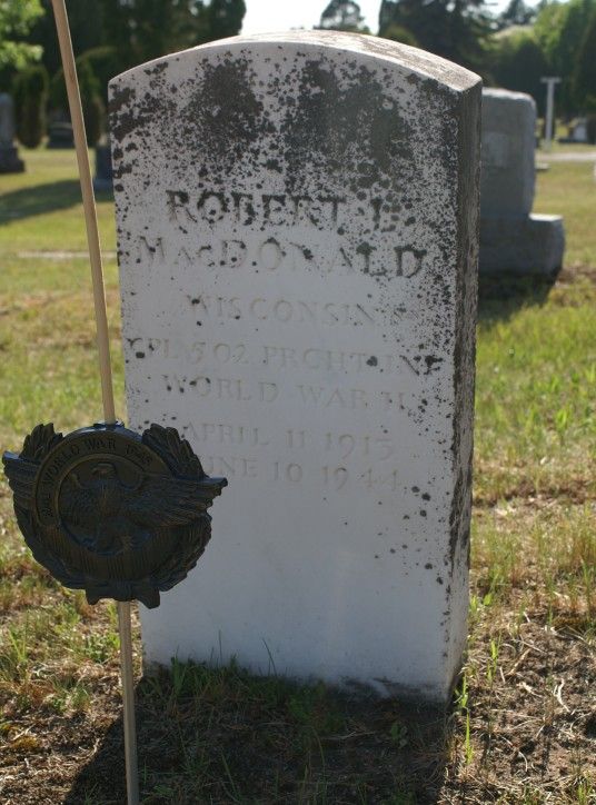
An evening stroll in the cemetery last week brought this timely acquaintance:


Robert L. MacDonald
Cpl. 502 Parachute Infantry
April 11, 1915
June 10, 1944

Twenty-four-hour access to hot and cold running information enabled me to find out what Cpl. MacDonald' s unit was doing on the day of his death.

Four days after D-Day, the 502nd Parachute Infantry Regiment, a unit of the 101st Airborne Division, was ordered to capture the crossroads town of Carentan, essential to provide a link between the Omaha and Utah landing beaches.

The approach to Carentan traversed an exposed causeway, with marshes on either side. At the head of the causeway, German troops had entrenched themselves in a farmhouse. Snipers hid in the marshes and orchards flanking the approach, and at least one of the Wehrmacht's feared 88mm guns was poised to devastate the approaching Americans.

According to The 101st Airborne During WWII:
The 3d Battalion, 502d PIR, led the... drive along the causeway. Progress, however, was extremely slow. The men of the 502d advanced along the causeway with no cover, facing steady fire as they moved forward. The battalion inched along until it reached the bridge on the Madeleine River and ran into a strong enemy position concentrated in an old farmhouse and the adjoining hedgerows.

Lt. Col. Robert G. Cole, the battalion commander, called for artillery fire on the position, but it did no good. Pinned down, he ordered a charge with fixed bayonets. Colonel Cole leapt up to lead the charge, but not all his men had gotten the word. The executive officer prodded the men along, and Cole continued with the soldiers that had followed. The Germans withdrew from the farmhouse, and the charging soldiers cleared the hedgerow positions. Cole was awarded the Medal of Honor for his efforts that day. Unfortunately, he was killed in a later division operation before receiving his medal.
Further, from Wikipedia:
Nightfall ended the advance but not the casualties, when an attack at 23:30 by two low-flying German Ju 87 Stukas strafing the causeway knocked "Item" Company completely out of the battle.

The severe casualties suffered by the 3rd/502d PIR, estimated at 67% of the original force, resulted in the nickname "Purple Heart Lane" applied to that portion of the Carentan-Sainte-Mère-Église highway.
And somewhere in all this, 65 years ago today, a young man from Washburn, Wisconsin, gave his life.

Tuesday, May 26, 2009

Gone Home: a brief review

Gone Home: Southern Folk Gravestone Art is a good book, but a deceptively titled one. The word "southern" suggests it's going to provide examples from across the southern United States; in reality it focuses exclusively on cemeteries in the state of Alabama.

Similarly, the phrase "gravestone art" implies the authors are going to focus on the decorative elements of funerary art: statuary, carvings, headstone shapes and styles, and so on. Instead, the authors' passion lies in epitaphs. The authors do discuss carving, but the focus seems to be more on the development of the lettering used in epitaphs rather than on the decorative elements of a marker such as floral motifs and Christian symbolism. There is also an interesting discussion of folklore and memorialization, and the evolution of markers and inscriptions over time.

Nonetheless, while the book is a useful one for anyone interested in gravestones and the history of memorialization, a reader looking for a book that focuses on gravestone art overall rather than the content of the inscriptions would be doomed to disappointment. Similarly, anyone hoping for a book that provides a regional context should look elsewhere. This is a good book on a specific subject area, and as such as fairly limited in its content.

Sunday, April 19, 2009

A Slight But Relevant Digression

An article in yesterday's New York Times provides one more illustration of a shift in American culture:

The Funeral: Your Last Chance to Be a Big Spender
Mr. Firnstein also says he is fielding more calls from families interested in natural burials. Adherents of the movement wrap bodies in simple shrouds or in biodegradable coffins and bury them in woodland cemeteries.

Such simple burials are traditional in many faiths, and were long the standard practice in the United States until the Civil War, when the development of modern embalming and the expansion of the train system altered the landscape of death and gave rise to the modern mortuary practice.
Read that last sentence again: "...the expansion of the train system altered the landscape..."

A generation ago, the reporter almost certainly would have written, "the expansion of the railroad network."

This is not a matter of enthusiast nit-picking; rather I submit that it is further evidence of the retreat of the railroads from their once-central position in American life. People just don't think much about railroads anymore; consequently, standardized terms of discourse that were once familiar to all have been forgotten and reporters grab for new ones on the fly.

Back to topic: my head exploded when I read this part about the trend to simpler and cheaper funerals:
“Back in the day, families might spend $10,000, $12,000 on a solid African mahogany casket, have an all-out wake and such,” (funeral director Jerry Sullivan) says. “Those days are over.”

Today, many funeral directors offer hardwood or metal rental coffins for a short period before cremation, Mr. Sullivan says. He charges roughly $1,000 to rent a hardwood casket for a daylong viewing; a body is placed in a combustible container of cardboard or soft wood, and inserted into the rental coffin lined with fabric.
A thousand bucks to rent a wooden box for one day? You could rent a house for a month for less than that around here.

Friday, April 3, 2009

Durability?

This is a wonderful marker, but I'm wondering what it's going to look like in 100 years. The marker is in the Bonaventure Cemetery, Savannah, Georgia.

Sunday, March 29, 2009

Union Church Cemetery, Pleasant Hill, Mississippi

The Union Church Cemetery near Pleasant Hill, Mississippi, has a nice assortment of metal markers.
Photos were taken March 23 by Ray Mannikko. Ray estimates the obelisk below was at least 8 feet tall.

The lamb below is the first I've seen in zinc. The grave also includes a metal footstone.


Tuesday, March 3, 2009

Bonaventure Cemetery, Savannah, Part II: Statuary

Bonaventure Cemetery has some lovely examples of funerary art, including these statues.

A slightly damaged angel:

One of the better known monuments in the cemetery:


Two examples of bas relief:


The cemetery also has an impressive number of bronzes. I'll include a few in a future post.

Wednesday, February 18, 2009

Bonaventure Cemetery, Savannah, Part I: Gothics

Bonaventure Cemetery in Savannah, Georgia, is the first cemetery I've ever wandered into that was actually crawling with tourists. The ripple effect of Midnight in the Garden of Good and Evil apparently lingers on because there were a lot of people wandering around with cameras and guidebooks, all apparently focused on finding Johnny Mercer's grave while oblivious to the wonderful funerary art elsewhere in the cemetery.
I did not, however, go looking for anything mentioned in the book, and have no clue just where Mr. Mercer got planted. I just kind of wandered around, admiring the Gothic markers and other statuary. I'm not normally a big fan of Gothic, but Bonaventure has some truly nice pieces.
The bed grave above is unfortunately damaged. You can tell that at one time there was a piece of ornamentation inside the three-sided headstone, probably a cross, but it's gone now. There's also damage to the back of the marker.

The majority of the grave markers at Bonaventure, however, are in remarkably good condition. I was expecting to see a fair amount of sugaring, but maybe the wind isn't from the right direction for the acid rain from the pulp mills and other Savannah industries to hit the marble. The damage that was visible tended to be pieces broken off, e.g., angels' fingers, rather than weathering.
Bonaventure Cemetery was originally a private cemetery located on a plantation near Savannah operated under the name of Evergreen Cemetery. The City of Savannah purchased the cemetery in 1907, and changed the name to Bonaventure.
Photos were taken with a 35 mm camera on actual film.

Wednesday, January 7, 2009

Maple Hill Cemetery, Huntsville, Alabama

The Maple Hill Cemetery in Huntsville, Alabama, is the oldest cemetery in the city. Located on the edge of a historic district, the cemetery is listed on the National Register of Historic Places. It includes a number of notable grave markers, including these three cast zinc headstones (front above, back below).
I looked for a company name, but could not find one. The one thing that stood out was they seemed to be cast from heavier gauge metal than most of the cast zinc (aka white bronze) markers I've seen elsewhere.

The cemetery also includes more angels in various poses than I'm used to seeing, ranging from the relatively small and cherubic, as shown below, to monumental in every sense of the word.

Adult varieties come kneeling or standing, looking humbly down
or beseechingly (expectantly?) up:
I've never really understood why the kneeling on only one knee.

Maple Hill does include some elements that definitely had me wondering what people were thinking. As we were driving through the cemetery we spotted this monument with the book on a stick (interpretive plaque) standing next to it.

Knowing that Maple Hill is a National Register property, and also knowing that various Alabama notables are interred in the cemetery, a visitor's natural reaction is, oh, good, they've put up a wayside that gives more information about either the cemetery or that particular monument. The visitor is doomed to disappointment.

The marker commemorates the 1807 establishment of the Huntsville meridian, "which is the reference point for all property surveyed in North Alabama." How the marker commemorating the meridian wound up sitting in the middle of the cemetery is a mystery -- a meridian is a line, so there's no logical reason why the marker has to be in what is without a doubt the one place in Huntsville where it is likely to be seen by the smallest number of potential viewers.