Tuesday, December 1, 2009

Clark-Dickey-Smith cemeteries, Sabine County, Texas


This is an odd site in Sabine County, Texas:  two cemeteries located literally spitting distance from each other.  In urban terms, they're less than half a standard city block apart.  No other traces of a community remain so it's difficult to say how they were located historically, e.g., were they once separated by a road?  As the book-on-a-stick notes, at one time a settlement existed that included several families.  I'm told there was also a cane mill, but no evidence of that settlement other than the cemeteries exists today. 

The Clark-Dickey cemetery is larger and, at a guess, appears to have been used for a longer time.  There are a number of fieldstone markers in addition to the commercial stones.  The cast concrete markers with hand lettering appear to be fairly recent, and may have been added at about the same time the historical marker was planted.

The Clark-Dickey cemetery includes half a dozen or so of the vernacular cast concrete tablet style markers like the one shown below; none were made using lettering kits.


Both cemeteries are surrounded by chain-link fence that's fairly new and in generally good condition, although a tree had fallen recently (within the past year) on the fencing for the Smith cemetery. 


The photo above is from the Smith Cemetery; it's the most noticeable grave there.  No inscription was visible on the tablet. 

The book-on-a-stick erected by the Texas Historical Commission suggests that both cemeteries began as family cemeteries, but notes a connection between the two, making it even odder that they're physically separate.  Local sources suggested that the fencing is wrong, the two cemeteries were connected, and more graves exist than are currently known or marked.  Whether or not that's true would require a thorough archeological survey, including the use of ground penetrating radar, a highly unlikely scenario given that both cemeteries appear to fall within the Sandy Creek riparian zone and are thus unlikely to be impacted by any future logging operations on that portion of the Forest. 

Both cemeteries are located on the Sabine National Forest.

Monday, November 2, 2009

Roadside Memorial, M-38, Upper Michigan


Roadside memorials have intrigued me for years with their odd mix of paganism and Christianity.  With the exception of the descanos erected in regions with sizable Hispanic populations, like New Mexico, the typical roadside memorial tended to be both spontaneous and ephemeral: a flimsy cross that quickly breaks down, a few flowers, occasionally some empty beer cans or a piece of the car the person died in.  That's been changing, as this memorial to Edward Disney evidences. 

Mr. Disney died in a traffic accident in 2002, 7 years before I took these photos.  The memorial remains well-maintained, with a large area along the right-of-way kept mowed so the cross continues to be highly visible.  One thing that surprises me, though, given the amount of time and effort that went into creating the memorial and its maintenance, is that the lettering has been allowed to fade.  It's no longer legible from more than a foot or two away. 

The memorial is located on the northside right-of-way for M-38 in Baraga County, Michigan, east of Alston, west of Baraga, and close to the Pine Creek Road. 

Monday, September 14, 2009

Along the Natchez Trace

This sad little family cemetery is located about 12 miles from Natchez along the Natchez Trace. Every marked grave inside the iron fence is for a child. Most are bed graves.
The dates span about a 20 year period just prior to the Civil War, all from the same family, the Brandons. In at least one case, two children died within a week of each other, suggesting they succumbed to an infectious disease such as a diptheria or measles (it was too early in the year for it to have been yellow fever).
The large table grave is for a son who made it to the age of 18.

The markers are in remarkably good shape in terms of weathering, but have experienced vandalism.

[The cemetery is not normally a pond -- I just happened to stop immediately after a really heavy rainfall.]

Friday, July 24, 2009

A grave house in Tennessee

When I first saw this structure from a distance, I thought it was the roof for a maintenance shed or pump house. The Pettit Cemetery is on a hillside, and from the road all that's visible is the roof. It wasn't until I walked into the cemetery that it became clear it was a grave house, and a fairly recent one. There appear to be two traditional in-ground graves in the house, complete with markers, but I didn't feel comfortable flopping on to the ground* to shoot a photo through the gap between the foundation and the roof. The cemetery itself, the Pettit Cemetery is located in the Land Between the Lakes in Tennessee with Dover, Tennessee, being the nearest town (perhaps 15 miles away) of any size. It is a fairly typical rural family cemetery, with the usual mix of commercial stones. I'm always intrigued by grave goods, and there were a few examples. It's becoming increasingly clear that the dead collect angels, as I see them in a lot of cemeteries. Lady Lenz (black headstone) is kind of an exception in having raccoons.
[ *An aversion to chiggers and woodticks stopped me from even dropping to my knees.]

Wednesday, July 22, 2009

Do it yourself funerals


Interesting article in the New York Times about the growing trend of families going back to burying their dead themselves. It includes a mention of a coffin-maker who builds lovely dual purpose wood furniture -- book shelves while you're alive; biodegadable box to plant you in once you're dead.

Saturday, July 18, 2009

Fort Donelson National Cemetery, Dover, Tennessee

The superintendent's house at Fort Donelson National Cemetery. It now houses administrative offices. (Sorry about the shortened chimneys; I was using a new camera and am still figuring out just how to frame shots before hitting the shutter release.) Wayside giving an overview of the cemetery.
Fort Donelson is now an inactive cemetery, which means all the grave sites are either occupied or spoken for.

Another view of the superintendent's house. The markers in the foreground mark the graves of unknown soldiers and are laid out in a pattern that resembles a heart.

Photos were taken June 27, 2007.

Wednesday, June 10, 2009

Anniversary For A Neighbor

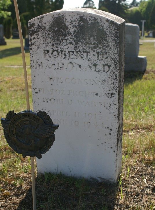
An evening stroll in the cemetery last week brought this timely acquaintance:


Robert L. MacDonald
Cpl. 502 Parachute Infantry
April 11, 1915
June 10, 1944

Twenty-four-hour access to hot and cold running information enabled me to find out what Cpl. MacDonald' s unit was doing on the day of his death.

Four days after D-Day, the 502nd Parachute Infantry Regiment, a unit of the 101st Airborne Division, was ordered to capture the crossroads town of Carentan, essential to provide a link between the Omaha and Utah landing beaches.

The approach to Carentan traversed an exposed causeway, with marshes on either side. At the head of the causeway, German troops had entrenched themselves in a farmhouse. Snipers hid in the marshes and orchards flanking the approach, and at least one of the Wehrmacht's feared 88mm guns was poised to devastate the approaching Americans.

According to The 101st Airborne During WWII:
The 3d Battalion, 502d PIR, led the... drive along the causeway. Progress, however, was extremely slow. The men of the 502d advanced along the causeway with no cover, facing steady fire as they moved forward. The battalion inched along until it reached the bridge on the Madeleine River and ran into a strong enemy position concentrated in an old farmhouse and the adjoining hedgerows.

Lt. Col. Robert G. Cole, the battalion commander, called for artillery fire on the position, but it did no good. Pinned down, he ordered a charge with fixed bayonets. Colonel Cole leapt up to lead the charge, but not all his men had gotten the word. The executive officer prodded the men along, and Cole continued with the soldiers that had followed. The Germans withdrew from the farmhouse, and the charging soldiers cleared the hedgerow positions. Cole was awarded the Medal of Honor for his efforts that day. Unfortunately, he was killed in a later division operation before receiving his medal.
Further, from Wikipedia:
Nightfall ended the advance but not the casualties, when an attack at 23:30 by two low-flying German Ju 87 Stukas strafing the causeway knocked "Item" Company completely out of the battle.

The severe casualties suffered by the 3rd/502d PIR, estimated at 67% of the original force, resulted in the nickname "Purple Heart Lane" applied to that portion of the Carentan-Sainte-Mère-Église highway.
And somewhere in all this, 65 years ago today, a young man from Washburn, Wisconsin, gave his life.